BUILDING RISK KNOWLEDGE
WHY THE FOUNDATION WAS BORN? >
WHY THE FOUNDATION WAS BORN? >
DISASTERS ARE NOT NATURAL, they are socially built, due to lack of preparation, prevention, mitigation work, education and monitoring. They are natural risks or hazards that impact vulnerable societies. Knowledge help reducing social and structural vulnerability in order to have more resilient societies!
InSAR (Interferometric Synthetic Aperture Radar) is a technique for mapping ground deformation using radar images of the Earth’s surface collected by orbiting satellites. Unlike visible or infrared light, radar waves penetrate most weather clouds and are equally effective in the dark. With InSAR, it is therefore possible to monitor ground deformation even in bad weather and at night – two big advantages during a volcanic crisis.
It is possible to compare two radar images of the same area, collected at different times from similar vantage points in space. Any movement of the ground surface towards or away from the satellite can be measured and represented as an ‘image’ – not of the surface itself, but of the amount of movement (deformation) of the surface between two images. The images are provided by space agencies in Italy, Germany, Canada, Japan, Korea, Europe and the USA.
To create this radar deformation “image”, a pulse of radar energy is emitted by a satellite, scattered by the Earth’s surface and recorded by the satellite with two types of information: amplitude and phase. The amplitude is the strength of the return signal, influenced by the physical properties of the surface. The round-trip distance between the satellite and the ground is measured in units of radar wavelength, and changes in this distance between the time two radar images were collected appear as a phase difference. The combination of these two images is called “interference” because the combination of two waves has the effect of reinforcing or cancelling them.
InSAR greatly expands scientists’ ability to monitor volcanoes because, unlike other techniques that rely on measurements at a few points, InSAR produces a map of ground deformation that covers a very large spatial area with centimetre accuracy. This technique is particularly useful for remote and hard-to-reach volcanoes, as well as for locations where hazardous conditions prevent or limit ground-based volcano monitoring.

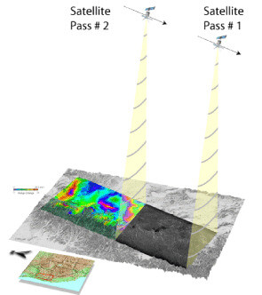
A satellite passes over an area and records data about it. Two or more passes are needed to create the InSAR images we use to examine changes in ground height.

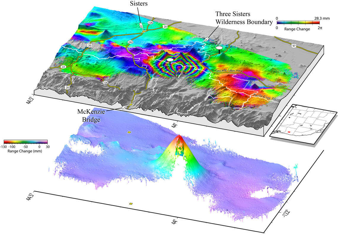
Interferogram image made from InSAR monitoring, showing 1995-2001 ground-uplift pattern centered 5 km (3 mi) west of South Sister volcano, Oregon.
VOLCANO ACTIVE FOUNDATION RESPONSABILITY
nº 2195 authorised by the Madrid's Minister of Justice
NIF G67314625
SF Abocados Francesc Macia 7 pl17
08029 Barcelona, Spain
We may request cookies to be set on your device. We use cookies to let us know when you visit our websites, how you interact with us, to enrich your user experience, and to customize your relationship with our website.
Click on the different category headings to find out more. You can also change some of your preferences. Note that blocking some types of cookies may impact your experience on our websites and the services we are able to offer.
These cookies are strictly necessary to provide you with services available through our website and to use some of its features.
Because these cookies are strictly necessary to deliver the website, refusing them will have impact how our site functions. You always can block or delete cookies by changing your browser settings and force blocking all cookies on this website. But this will always prompt you to accept/refuse cookies when revisiting our site.
We fully respect if you want to refuse cookies but to avoid asking you again and again kindly allow us to store a cookie for that. You are free to opt out any time or opt in for other cookies to get a better experience. If you refuse cookies we will remove all set cookies in our domain.
We provide you with a list of stored cookies on your computer in our domain so you can check what we stored. Due to security reasons we are not able to show or modify cookies from other domains. You can check these in your browser security settings.
These cookies collect information that is used either in aggregate form to help us understand how our website is being used or how effective our marketing campaigns are, or to help us customize our website and application for you in order to enhance your experience.
If you do not want that we track your visit to our site you can disable tracking in your browser here:
We also use different external services like Google Webfonts, Google Maps, and external Video providers. Since these providers may collect personal data like your IP address we allow you to block them here. Please be aware that this might heavily reduce the functionality and appearance of our site. Changes will take effect once you reload the page.
Google Webfont Settings:
Google Map Settings:
Google reCaptcha Settings:
Vimeo and Youtube video embeds:
The following cookies are also needed - You can choose if you want to allow them:
You can read about our cookies and privacy settings in detail on our Privacy Policy Page.
PRIVACY POLICY