https://volcanofoundation.org/wp-content/uploads/2019/09/Captura-de-pantalla-2019-09-09-a-las-16.21.23.png
2208
3088
Anne Fornier
https://volcanofoundation.org/wp-content/uploads/2021/04/volcano-foundation-1-1.png
Anne Fornier2019-04-04 14:06:182021-09-27 17:30:19THE PARICUTIN VOLCANO. TRAILS AND INTERPRETATION.
https://volcanofoundation.org/wp-content/uploads/2019/09/Captura-de-pantalla-2019-09-09-a-las-16.21.23.png
2208
3088
Anne Fornier
https://volcanofoundation.org/wp-content/uploads/2021/04/volcano-foundation-1-1.png
Anne Fornier2019-04-04 14:06:182021-09-27 17:30:19THE PARICUTIN VOLCANO. TRAILS AND INTERPRETATION.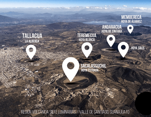 https://volcanofoundation.org/wp-content/uploads/2019/04/image-5.png
382
576
Anne Fornier
https://volcanofoundation.org/wp-content/uploads/2021/04/volcano-foundation-1-1.png
Anne Fornier2019-04-04 14:04:492021-09-27 17:30:31THE SEVEN LUMINARIES. CRATERS BETWEEN VILLAGES.
https://volcanofoundation.org/wp-content/uploads/2019/04/image-5.png
382
576
Anne Fornier
https://volcanofoundation.org/wp-content/uploads/2021/04/volcano-foundation-1-1.png
Anne Fornier2019-04-04 14:04:492021-09-27 17:30:31THE SEVEN LUMINARIES. CRATERS BETWEEN VILLAGES.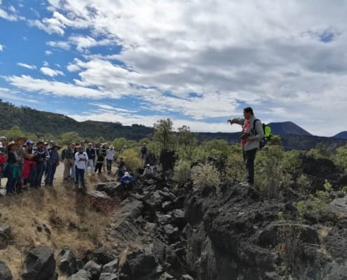 https://volcanofoundation.org/wp-content/uploads/2019/04/red-vulcanologos-volcanofoundation-1-1500x1125.jpg
1125
1500
Anne Fornier
https://volcanofoundation.org/wp-content/uploads/2021/04/volcano-foundation-1-1.png
Anne Fornier2019-04-04 12:47:462021-09-27 17:30:43INTERNATIONAL NETWORK OF VOLCANO GUIDES
https://volcanofoundation.org/wp-content/uploads/2019/04/red-vulcanologos-volcanofoundation-1-1500x1125.jpg
1125
1500
Anne Fornier
https://volcanofoundation.org/wp-content/uploads/2021/04/volcano-foundation-1-1.png
Anne Fornier2019-04-04 12:47:462021-09-27 17:30:43INTERNATIONAL NETWORK OF VOLCANO GUIDES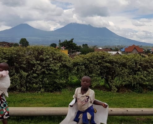 https://volcanofoundation.org/wp-content/uploads/2018/12/volcano-foundation-news-05.jpg
1080
1920
Anne Fornier
https://volcanofoundation.org/wp-content/uploads/2021/04/volcano-foundation-1-1.png
Anne Fornier2019-04-03 16:24:092021-09-27 17:31:10NATURAL HAZARDS IN GOMA AND THE SURROUNDING VILLAGES
https://volcanofoundation.org/wp-content/uploads/2018/12/volcano-foundation-news-05.jpg
1080
1920
Anne Fornier
https://volcanofoundation.org/wp-content/uploads/2021/04/volcano-foundation-1-1.png
Anne Fornier2019-04-03 16:24:092021-09-27 17:31:10NATURAL HAZARDS IN GOMA AND THE SURROUNDING VILLAGES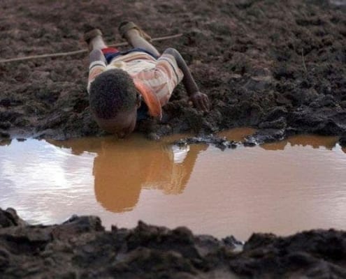 https://volcanofoundation.org/wp-content/uploads/2019/08/contaminacion-agua-volcan-africa.jpg
437
720
Anne Fornier
https://volcanofoundation.org/wp-content/uploads/2021/04/volcano-foundation-1-1.png
Anne Fornier2019-04-03 15:48:212021-09-27 17:31:24INFLUENCE OF MOISTURE SOURCE DYNAMICS AND WEATHER PATTERNS IN CENTRAL-EASTERN AFRICA
https://volcanofoundation.org/wp-content/uploads/2019/08/contaminacion-agua-volcan-africa.jpg
437
720
Anne Fornier
https://volcanofoundation.org/wp-content/uploads/2021/04/volcano-foundation-1-1.png
Anne Fornier2019-04-03 15:48:212021-09-27 17:31:24INFLUENCE OF MOISTURE SOURCE DYNAMICS AND WEATHER PATTERNS IN CENTRAL-EASTERN AFRICA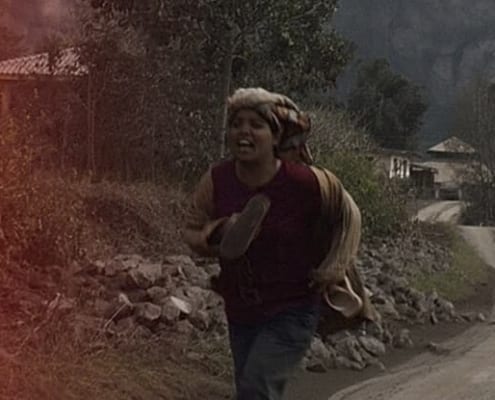 https://volcanofoundation.org/wp-content/uploads/2019/03/tira-claim-bg.jpg
415
1800
Anne Fornier
https://volcanofoundation.org/wp-content/uploads/2021/04/volcano-foundation-1-1.png
Anne Fornier2019-02-19 12:12:172021-09-27 17:32:32VEI HOW DO YOU RATE THE STRENGTH OF AN ERUPTION?
https://volcanofoundation.org/wp-content/uploads/2019/03/tira-claim-bg.jpg
415
1800
Anne Fornier
https://volcanofoundation.org/wp-content/uploads/2021/04/volcano-foundation-1-1.png
Anne Fornier2019-02-19 12:12:172021-09-27 17:32:32VEI HOW DO YOU RATE THE STRENGTH OF AN ERUPTION?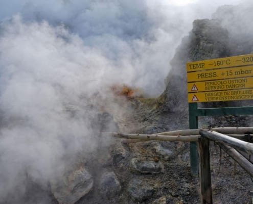 https://volcanofoundation.org/wp-content/uploads/2019/02/Volcano-active-foundation-campi-flegrei.jpg
1200
1920
Anne Fornier
https://volcanofoundation.org/wp-content/uploads/2021/04/volcano-foundation-1-1.png
Anne Fornier2019-02-18 17:07:142021-09-27 17:32:43CAMPI FLEGREI, A TICKING TIME BOMB
https://volcanofoundation.org/wp-content/uploads/2019/02/Volcano-active-foundation-campi-flegrei.jpg
1200
1920
Anne Fornier
https://volcanofoundation.org/wp-content/uploads/2021/04/volcano-foundation-1-1.png
Anne Fornier2019-02-18 17:07:142021-09-27 17:32:43CAMPI FLEGREI, A TICKING TIME BOMB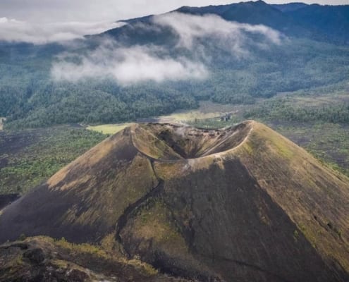 https://volcanofoundation.org/wp-content/uploads/2019/01/50609801_124290811952835_4551867685318688768_o.jpg
1958
2048
Anne Fornier
https://volcanofoundation.org/wp-content/uploads/2021/04/volcano-foundation-1-1.png
Anne Fornier2019-01-23 11:03:272021-09-27 17:39:35HOW A VOLCANO IS CREATED? THE HISTORY OF PARICUTÍN
https://volcanofoundation.org/wp-content/uploads/2019/01/50609801_124290811952835_4551867685318688768_o.jpg
1958
2048
Anne Fornier
https://volcanofoundation.org/wp-content/uploads/2021/04/volcano-foundation-1-1.png
Anne Fornier2019-01-23 11:03:272021-09-27 17:39:35HOW A VOLCANO IS CREATED? THE HISTORY OF PARICUTÍN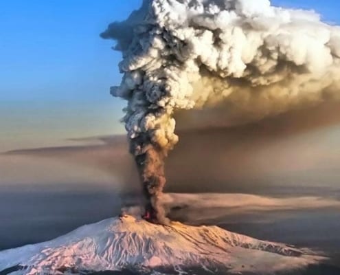 https://volcanofoundation.org/wp-content/uploads/2019/01/Etna-1024x550.jpg
550
1024
Anne Fornier
https://volcanofoundation.org/wp-content/uploads/2021/04/volcano-foundation-1-1.png
Anne Fornier2019-01-16 10:52:182021-09-27 17:40:55COULD ETNA CAUSE A TSUNAMI?
https://volcanofoundation.org/wp-content/uploads/2018/12/volcano-foundation-news-05.jpg
1080
1920
Anne Fornier
https://volcanofoundation.org/wp-content/uploads/2021/04/volcano-foundation-1-1.png
Anne Fornier2018-12-20 12:40:492021-09-27 17:48:16THE FERTILITY OF VOLCANOES
https://volcanofoundation.org/wp-content/uploads/2019/01/Etna-1024x550.jpg
550
1024
Anne Fornier
https://volcanofoundation.org/wp-content/uploads/2021/04/volcano-foundation-1-1.png
Anne Fornier2019-01-16 10:52:182021-09-27 17:40:55COULD ETNA CAUSE A TSUNAMI?
https://volcanofoundation.org/wp-content/uploads/2018/12/volcano-foundation-news-05.jpg
1080
1920
Anne Fornier
https://volcanofoundation.org/wp-content/uploads/2021/04/volcano-foundation-1-1.png
Anne Fornier2018-12-20 12:40:492021-09-27 17:48:16THE FERTILITY OF VOLCANOES