BUILDING RISK KNOWLEDGE
WHY THE FOUNDATION WAS BORN? >
WHY THE FOUNDATION WAS BORN? >
DISASTERS ARE NOT NATURAL, they are socially built, due to lack of preparation, prevention, mitigation work, education and monitoring. They are natural risks or hazards that impact vulnerable societies. Knowledge help reducing social and structural vulnerability in order to have more resilient societies!
Observing and measuring changes in the shape of a volcano’s surface (topography) helps scientists understand the processes that cause landforms to grow and erode. Scientists create highly accurate maps of the ground surface called digital elevation models (DEMs). Two or more DEMs covering the same area are used to monitor the topographic changes of several volcanoes. By comparing DEMs made at different times, scientists can calculate the volume of lava ejected or the rate of growth of an active volcano’s dome, monitor changes in glaciers, measure the thickness of debris flows, understand how sediments are transported in a river or stream bed, and monitor changes in channel shape.
DEMs are generated from three-dimensional topographic measurements made using remote sensing techniques, which means that the measuring devices or sensors are not in direct contact with the objects being measured. For example, DEMs can be made from photographs or overlaid satellite images of the ground surface or with instruments that take high-resolution elevation measurements using lasers.
DEMs help scientists locate ideal monitoring sites and produce maps of volcanic hazards.
On several volcanoes, topographic analysis using geographic information system (GIS) techniques has been used to determine appropriate locations for the installation of monitoring instrument stations. GIS calculations are used to map radio transmission paths for data to be sent from monitoring sites to the Volcano Observatory offices, to determine the optimal location for the interaction of the sun with solar panels, to identify helicopter landing zones and to measure the height of tree canopies.
Modelling is very important for understanding volcanic hazards. These models use DEMs as the base surface for computer simulations of pyroclastic flows, debris avalanches, lahars, floods and river sediment transport. The models allow scientists to produce maps of volcanic hazards, predict flooding from rainfall, snowfall and lake outbursts, and reduce the impacts of sediment accumulation in rivers and streams.
The problem remains that the cost of these monitoring operations is possible for so-called privileged countries and often unthinkable due to lack of resources in disadvantaged countries.

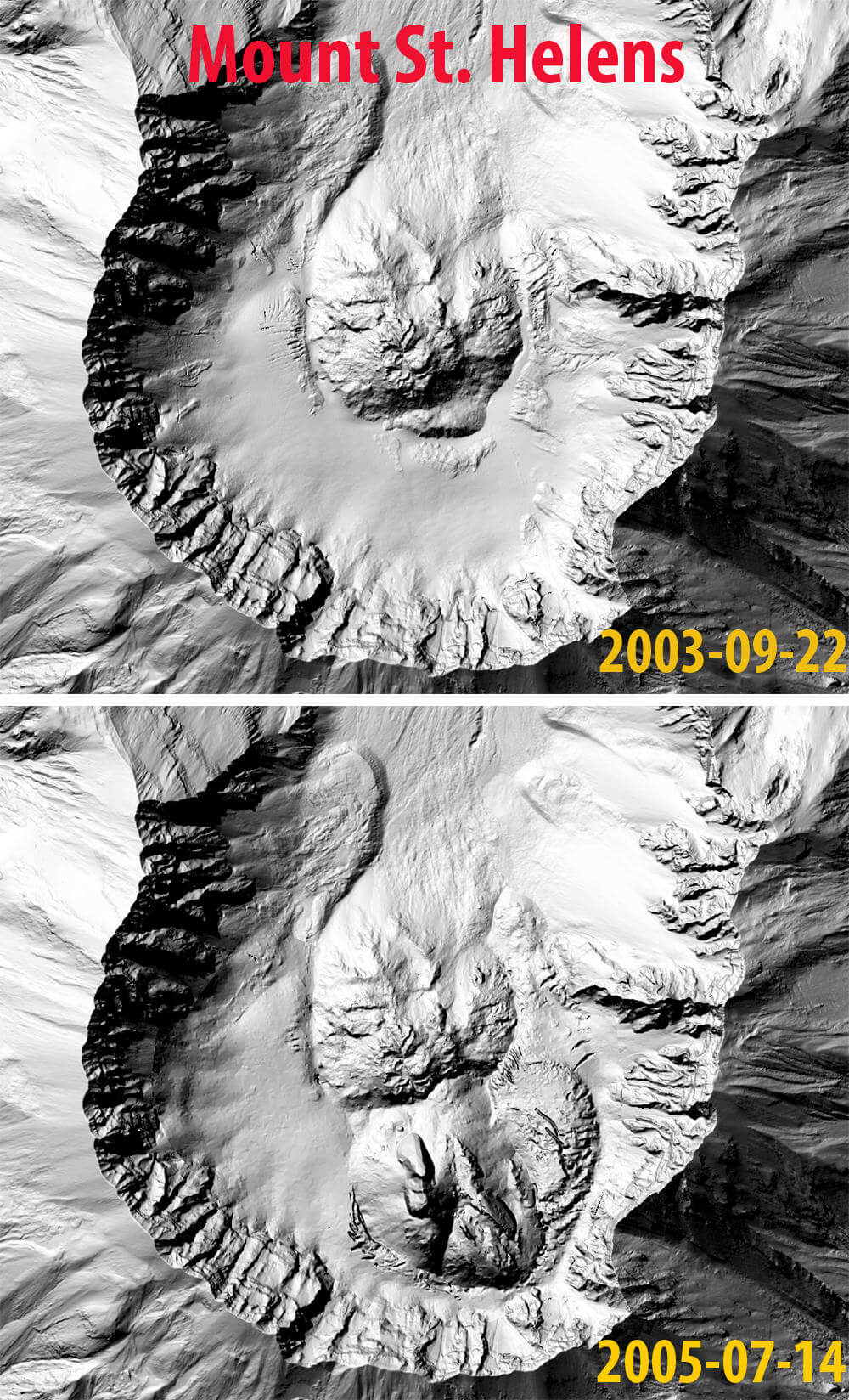
Dome building episode from 2004-2008 at Mount St. Helens can be observed and measured with these two digital elevation models (DEMs) developed before and after the eruptive episode.
In a process called photogrammetry, VHP scientists take digital overlay photographs of a volcano, which can be taken from the air or the ground. Thanks to recent advances in camera and computer technology, these images are used to construct DEMs quickly and accurately. This method is similar to the older technique of using analogue stereo cameras and comparing pairs of overlapping aerial photographs taken at the same time. The collection and processing of photographs to create DEMs can be done at relatively low cost.
Lasers can be used to map the ground surface under vegetation.
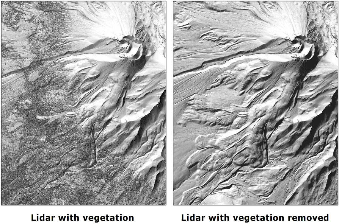
Light detection and ranging (lidar) technology uses laser scanners to measure ground surface elevation, which is used to generate very high resolution DEMs. Lasers are able to penetrate the forest canopy to the ground, so unlike photogrammetry methods, maps made using lidar reveal features of the land surface that are masked by digital photographs taken in densely vegetated or forested areas.
Lidar DEMs have been used to locate previously unknown faults, map pyroclastic flow deposits and groundwater. Most lidar scanners use near-infrared lasers that are absorbed by water, allowing scientists to map the characteristics of surface waters such as springs, rivers and lakes.

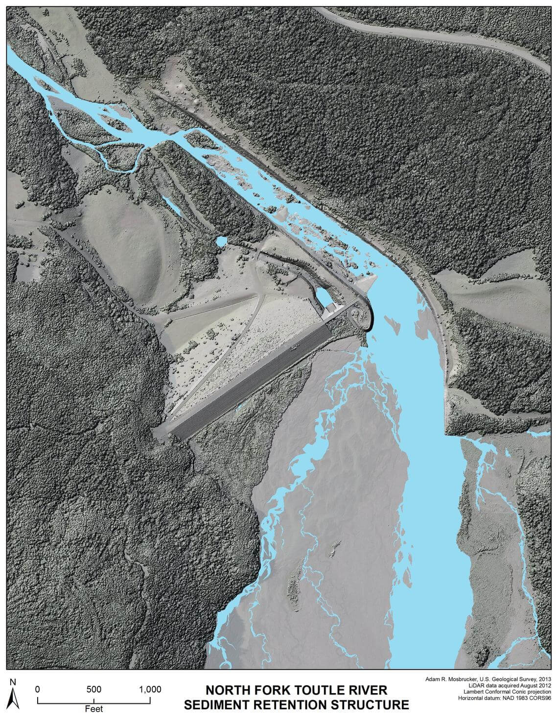
Highway 504 is shown in upper right.

Lidar images of Shastina cone, west flank of Mount Shasta, California. Details of lava flows and other surficial features are best seen in the image to the right with vegetation removed.
VOLCANO ACTIVE FOUNDATION RESPONSABILITY
nº 2195 authorised by the Madrid's Minister of Justice
NIF G67314625
SF Abocados Francesc Macia 7 pl17
08029 Barcelona, Spain
We may request cookies to be set on your device. We use cookies to let us know when you visit our websites, how you interact with us, to enrich your user experience, and to customize your relationship with our website.
Click on the different category headings to find out more. You can also change some of your preferences. Note that blocking some types of cookies may impact your experience on our websites and the services we are able to offer.
These cookies are strictly necessary to provide you with services available through our website and to use some of its features.
Because these cookies are strictly necessary to deliver the website, refusing them will have impact how our site functions. You always can block or delete cookies by changing your browser settings and force blocking all cookies on this website. But this will always prompt you to accept/refuse cookies when revisiting our site.
We fully respect if you want to refuse cookies but to avoid asking you again and again kindly allow us to store a cookie for that. You are free to opt out any time or opt in for other cookies to get a better experience. If you refuse cookies we will remove all set cookies in our domain.
We provide you with a list of stored cookies on your computer in our domain so you can check what we stored. Due to security reasons we are not able to show or modify cookies from other domains. You can check these in your browser security settings.
These cookies collect information that is used either in aggregate form to help us understand how our website is being used or how effective our marketing campaigns are, or to help us customize our website and application for you in order to enhance your experience.
If you do not want that we track your visit to our site you can disable tracking in your browser here:
We also use different external services like Google Webfonts, Google Maps, and external Video providers. Since these providers may collect personal data like your IP address we allow you to block them here. Please be aware that this might heavily reduce the functionality and appearance of our site. Changes will take effect once you reload the page.
Google Webfont Settings:
Google Map Settings:
Google reCaptcha Settings:
Vimeo and Youtube video embeds:
The following cookies are also needed - You can choose if you want to allow them:
You can read about our cookies and privacy settings in detail on our Privacy Policy Page.
PRIVACY POLICY