BUILDING RISK KNOWLEDGE
WHY THE FOUNDATION WAS BORN? >
WHY THE FOUNDATION WAS BORN? >
DISASTERS ARE NOT NATURAL, they are socially built, due to lack of preparation, prevention, mitigation work, education and monitoring. They are natural risks or hazards that impact vulnerable societies. Knowledge help reducing social and structural vulnerability in order to have more resilient societies!
Landslides are large masses of wet or dry rock and soil that fall, slide or sink very rapidly under the influence of gravity. Landslides usually take the form of massive rockfalls or avalanches, which disintegrate during their movement into fragments ranging from small particles to blocks several hundred metres in diameter. If the landslide is large enough and contains a sufficiently high percentage of water and fine material (typically >3-5 per cent clay-sized particles), it can develop into a lahar that can travel up to 200 km downstream.
Landslides are common on volcanic cones because they are high, steep and weakened by the rising and eruption of molten rock. The magma releases volcanic gases that partially dissolve into the groundwater, creating a hot, acidic hydrothermal system that weakens the rock by turning the minerals into clay. In addition, the mass of thousands of layers of lava and fragmented rock debris can lead to frequently shifting fault zones.
Volcano landslides (debris avalanches) range in size from less than 1 km3 to more than 100 km3 . The high speed and momentum of landslides allow them to cross watersheds and travel up slopes of several hundred metres. For example, the landslide that occurred on 18 May 1980 at Mount St Helens had a volume of 2.5 km3 , reached speeds of 50-80 m/s and surged up slopes of several hundred metres.

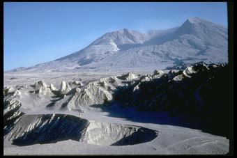
After the May 18, 1980 eruption, Mount St. Helens’ elevation was only 8,364 feet (2,550 meters) and the volcano had a one-mile-wide (1.5 kilometers) and approximately 600 m (2000 ft) deep horseshoe-shaped crater. View here is from the northwest.

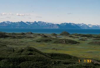
Hummocks on West Island, Alaska, 8 km (5 mi) WNW from Augustine Volcano summit. These small hills were deposited as part of the 1883 debris avalanche (landslide) that triggered a Cook Inlet tsunami.

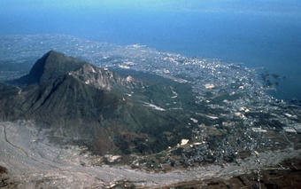
Landslide scarp on Mt. Mayuyama, part of the Unzen Volcano complex – Kyushu Island, Japan. East flank collapsed May 21, 1792 and a landslide swept through Shimabara City to the sea forming a tsunami.
Several conditions can trigger landslides:

Early on the morning of May 18, 1980, the landslide swept into the upper North Fork Toutle River valley and came to rest within about 22 km of the volcano. The landslide deposit, however, was saturated with water and contained snow and ice blocks from the volcano’s former glaciers. As soon as the landslide stopped moving, water percolated to the top of the deposit and poured across its irregular surface, forming many lahars that merged as they rushed down the valley. The peak flow swept from the deposit about 5 hours after the landslide was emplaced!
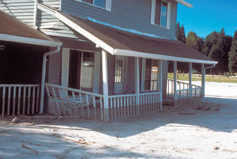
The lahar flowed down the Toutle River throughout the afternoon and evening, reaching its peak at midnight about 60 km downstream from the volcano. The lahar destroyed roads, bridges, and homes
By removing a large part of a volcano’s cone, a landslide can abruptly decrease the pressure on shallow magma and hydrothermal systems, which can generate explosions ranging from small steam explosions to large steam- and magma-driven explosions. These lead to the risk of tephra and ash falling into the surrounding areas.
Large landslides often bury valleys with tens to hundreds of metres of rock debris, forming a chaotic landscape marked by dozens of small hills (hummocks) and closed depressions. If the deposit is thick enough, it can dam up tributary streams to form lakes; these can eventually drain catastrophically, forming lahars and floods downstream. Landslides also generate some of the largest and most deadly lahars, either by becoming a lahar directly or, after ceasing to move, by breaking away from the deposit.
Historically, the deadliest volcanic landslide occurred in 1792, when sliding debris from Mount Mayuyama, near Unzen volcano in Japan, crashed into the Ariaka Sea and generated a tsunami that reached the opposite shore and killed nearly 15,000 people.
Large horseshoe-shaped craters, open at one end, have long been observed in many volcanic regions of the world. The origin of these open craters is controversial, but since the debris avalanche and eruption of Mount St Helens in 1980, scientists believe that many of them formed as a result of landslides. If the primary eruptive vent is located within these deep craters, it is likely to direct subsequent volcanic activity (lava flows, pyroclastic flows or lahars) towards its broken opening.
VOLCANO ACTIVE FOUNDATION RESPONSABILITY
nº 2195 authorised by the Madrid's Minister of Justice
NIF G67314625
SF Abocados Francesc Macia 7 pl17
08029 Barcelona, Spain
We may request cookies to be set on your device. We use cookies to let us know when you visit our websites, how you interact with us, to enrich your user experience, and to customize your relationship with our website.
Click on the different category headings to find out more. You can also change some of your preferences. Note that blocking some types of cookies may impact your experience on our websites and the services we are able to offer.
These cookies are strictly necessary to provide you with services available through our website and to use some of its features.
Because these cookies are strictly necessary to deliver the website, refusing them will have impact how our site functions. You always can block or delete cookies by changing your browser settings and force blocking all cookies on this website. But this will always prompt you to accept/refuse cookies when revisiting our site.
We fully respect if you want to refuse cookies but to avoid asking you again and again kindly allow us to store a cookie for that. You are free to opt out any time or opt in for other cookies to get a better experience. If you refuse cookies we will remove all set cookies in our domain.
We provide you with a list of stored cookies on your computer in our domain so you can check what we stored. Due to security reasons we are not able to show or modify cookies from other domains. You can check these in your browser security settings.
These cookies collect information that is used either in aggregate form to help us understand how our website is being used or how effective our marketing campaigns are, or to help us customize our website and application for you in order to enhance your experience.
If you do not want that we track your visit to our site you can disable tracking in your browser here:
We also use different external services like Google Webfonts, Google Maps, and external Video providers. Since these providers may collect personal data like your IP address we allow you to block them here. Please be aware that this might heavily reduce the functionality and appearance of our site. Changes will take effect once you reload the page.
Google Webfont Settings:
Google Map Settings:
Google reCaptcha Settings:
Vimeo and Youtube video embeds:
The following cookies are also needed - You can choose if you want to allow them:
You can read about our cookies and privacy settings in detail on our Privacy Policy Page.
PRIVACY POLICY