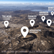
THE PARICUTIN VOLCANO. TRAILS AND INTERPRETATION.
The Paricutin volcano is one of the precursors of modern volcanology, appearing in 1943 when a fissure opened in the middle of a crop with no apparent warning. This eruption was studied live by volcanologists who were later able to compare its products with the activity of the volcano. Since then it has become a focus of scientific and tourist attraction. Currently there is no coordinated management to access the volcano and the three communities that were most affected during the eruption, some displaced and all when their population was buried by the lava, are not coordinated for the management of visitors, trails and / or conservation of natural values. This is why the volcano has an erosion in its trails that each year is more accentuated.
What geoconservation in volcanoes is being promoted?
The knowledge of the volcano among the population that lives with Paricutin, create a plan for public use of the volcano and coordinate different actors related to the volcano.
Objectives
- Avoid erosion of the volcano along the trails.
- Improve the interpretation of the volcano.
- Analyze what conservation actions could be carried out among the three communities.
Actions
- Community observatory of the volcano to promote its conservation.
- Diagnosis of the community tourism promoted among the three communities of the volcano in partnership with Alba Sud.
- Restoration of trails and public use.
Expected results
- Improve access and landscape in the volcano.
- Improve the living conditions (material and spiritual) of the populations that live with the Paricutin.

